 |
 |
| current issue |  | past issues | | send a letter/news | | address update | | advertise | | about us | | alumni home |

Features
|
Final Frontier
Larry Mayer and his team of ocean-mapping researchers are unlocking the mysteries hidden by the world's oceans. Also read: Where's UNH Ocean Mapping? Everywhere |
Easy to print version Make a comment |
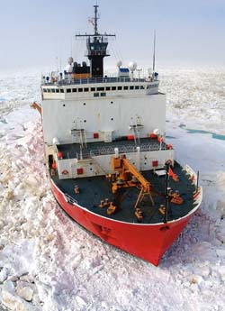 U.S. Coast Guard Cutter Healy courtesy photo |
In a glacier blue fleece jacket and a UNH baseball cap, Larry Mayer stands on the exposed foredeck of the 420-foot Healy, the U.S. Coast Guard's newest and largest polar icebreaker, looking oddly relaxed. He is in a remote corner of the globe—only a few miles off the low gray shore of Barrow, Alaska, the northernmost point in the United States—but it's a veritable hub compared to where he's going, an uninhabited place several hundred nautical miles north, where the cold is colder, the gray grayer, and the mental hardships from extended stays are so perverse they produce a rare medical condition known as "Long Eye." Science describes this as a vacant stare indicating that the individual is—in so many words—miserable.
Getting there won't be any picnic, either. Mayer's chief-scientist living quarters for the next six weeks aboard the Healy will be spartan; the mess area where he'll eat is often engulfed in the grindingly deafening sound caused by a 2-inch-thick steel hull crashing through sea ice 6 feet thick. Traversing the ship is an obstacle course of skull-cropping bulkheads and exposed hand-over-hand ladders, including the so-called "ladder of death," a slip-and-you'll-be-sorry shortcut. That the ship is stockpiled with an extra year's worth of food rations suggests that it isn't beyond anyone's imagination that the vessel could become icebound, locked in a frozen embrace of bergs and bears and released when and if the Arctic deems it so. At this very instant, only moments after he's come aboard, the weather is deteriorating. A spitting rain smears his glasses and gusts infiltrate his white turtleneck.
And he is pretty much loving every moment of it. He's about to show a National Geographic film crew around for its future series, "Alien Deep," but right now he is thinking about how lucky he felt as a helicopter ferried him to the ship's landing pad. "I've been going to sea for 34 years," he explains. "This"—he gestures happily toward the largely unmapped and unexplored and unloved sea around him—"is why I became an oceanographer."
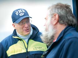 Perry Smith/UNH Photographic Services Larry Mayer, left, has a discussion with Dale Chayes, senior engineer from the Lamont Doherty Earth Observatory of Columbia University. |
It's mid-August 2011, and Mayer, the founding director of UNH's Center for Coastal and Ocean Mapping, is here along with nine other UNH researchers to embark on a 45-day seafloor survey of a strategically vital section of the high Arctic. The data Mayer and his team will acquire will be instrumental in identifying and negotiating future U.S. boundaries. "We look at a beach and we think that's where the country ends," says Mayer, explaining that the continent in fact often extends unknown distances beneath the sea. Seventy-one percent of the Earth's surface is covered by oceans, and most of it is a mystery. That mystery is what draws the UNH researchers to take long, arduous voyages like this one and spend uncounted hours in the lab, turning the data they collect into detailed marine charts and intuitive 3-D videos.
As the ship prepares to get underway, Mayer knows the icepack is lurking some 100 miles away—but he says he wouldn't be surprised to see it sooner. To the east a massive polar bear just swam past, headed for an exhausted landfall at Point Barrow's headland. Mayer didn't need to see the bear to be reminded how wild this place is. He is surrounded, pretty much everywhere he looks, by seafloor incognita. Even segments of the Alaskan coast near Barrow, an area that is seeing increased science expedition traffic, lack modern charting; some areas haven't been updated since Captain Cook plied these frigid waters in the 18th century.
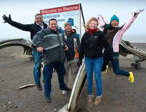 Perry Smith/UNH Photographic Services A GIANT LEAP FOR MANKIND: Indulging photographer Perry Smith, members of the UNH crew clown around in Barrow, Alaska. From left, Ecuadorean naval officer and graduate student Jorge Alavera, IT specialist Roland Arsenault, and graduate students Garrett Mitchell, Christy Fandel and Dandan Miao. |
There's real work to be done, and in the process, the six UNH graduate students in tow are about to get the experience of their lives. That the next generation of hydrographers is performing research here, and not some other ocean research venue like the sunny south Pacific, tells you something about both the scientific seduction of "farthest north" and the Mayer-led team.
"I don't know what the most intimidating thing for me is," says grad student Christy Fandel of Charlotte, N.C., before the ship's departure. "Maybe it's the length of time at sea. We're going to be out a long time." Fellow student Jorge Alavera, a lieutenant in the Ecuadorean navy who has surveyed the Amazon, is struck by how they will be plowing through seemingly immovable objects instead of around them. Fandel, Alavera and their fellow students are in that lovely scientific sweet spot of being in a place where everything is new. "My career was changed because somebody took me to sea," notes Mayer.
Easy to print version
blog comments powered by Disqus